San Francisco:Route
The July 2012 route is mostly nailed down. You can view preliminary route maps on our companion Facebook page. The route is quite different, covering new territory from previous rides.
Contents
Route Maps
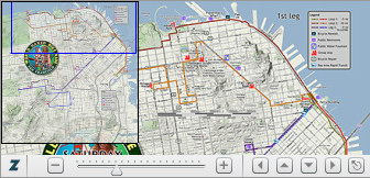
2012Northern Hemisphere Route (July)DescriptionTo be completed... Northern Hemisphere Route (June)DescriptionThe 1st leg is mostly on flat areas along the city's waterfront landmark areas like AT&T Park, the Ferry Building, Pier 39, Fisherman's Wharf, Aquatic Park and the Marina Green. There are those inevitable San Francisco hills though. A slight uphill wiggle is needed to get past Fort Mason on Bay. There is also a long stretch of mild grade that will be used to ascend to the Lombard Street curves through Polk Street and Larkin Street. It is not necessary to ride down these curves, and if you choose, just walk your bike up to Hyde on the last hill and walk it down the curves. Many hundreds of Critical Mass riders did this in the past May Critical Mass ride. Want an even tamer option? There will be a split point on Larkin St. where opting out of the Lombard curve will detour you down to the beginning of North Beach in front of Blazing Saddles Bike Rentals. Here the group will gather up again for the remainder of the first leg. After North Beach, there will be a loop around in the South Of Market area (SOMA), a brief run on Market Street to Castro District past Dolores Park to the finish point at the Castro/Market St. corner in the Jane Warner Plaza. The 1st Leg is about 18 miles long. If the first leg is enough riding, you are invited to rest up and take a break at the Jane Warner Plaza, which is clothing-optional. Those who want more riding are urged to continue on for the shorter 2nd leg, which is about 6 miles (40 minutes estimate, but with more hill climbing. Both 1st & 2nd legs take us down to the Castro/Market corner as the finish point. The second leg will take us up the Wiggle to the west end of Haight Street with a hopeful repeat of our successful patronage of Ben & Jerry's Ice Cream at the corner of Haight & Ashbury. Then the ride will return past Dolores Park again to rejoin with the other riders for a post-ride gathering in the Jane Warner Plaza. There are local businesses nearby with take-out food options: pizza, Chinese, Italian, deli, cookies, etc... View the route map using the Zoomify Flash Viewer.This allows you to zoom and pan the route map much the same way that Google maps does it. Won't work on iPads or iPhones.
|
View the route online via this JPEG image link.Or, download into your smart phone to view while on the ride, in case you lose the group, need to find a nearby bike repair shop, restroom or water fountain.
Online Turn SheetAn online turn sheet is available on our Facebook page. We ran out of time and we were not able to create a printable PDF version of it. 2011Northern Hemisphere Route Maps (June)View the route map using the Zoomify Flash Viewer.This allows you to zoom and pan the route map much the same way that Google maps does it. Won't work on iPads or iPhones.
Download the Turn Sheets in PDF format.
View the route online via these JPEG image links.Or, download into your smart phone to view while on the ride, in case you lose the group, need to find a nearby bike repair shop, restroom or water fountain.
Download the route maps in PDF format.Then print and take along with you on the ride.
|


