|
|
| Line 1: |
Line 1: |
| − | [[Home|Home]] > [[List_of_rides|List of rides]] > [[US|US]] > [[San_Francisco#Route|San Franscisco]] > Route[[Image:SF_WNBR_AD_728x90_A.jpg|left|728px|San Francisco WNBR Header]]
| + | {{Ride location sub-page breadcrumb|Country=US|RideLocation=San Francisco}} |
| | + | <br style="clear:both" /> |
| | + | |
| | + | |
| | + | [[Image:SF_WNBR_AD_728x90_A.jpg|left|728px|San Francisco WNBR Header]] |
| | <br style="clear:both" /> | | <br style="clear:both" /> |
| | We finally have the June 2011 route nailed down. We tried to use Google's map routing tool to do this but it was just a disaster. So, we are providing the route in a printable PDF format along with some JPEG images that you can view online. | | We finally have the June 2011 route nailed down. We tried to use Google's map routing tool to do this but it was just a disaster. So, we are providing the route in a printable PDF format along with some JPEG images that you can view online. |
Revision as of 10:15, 29 May 2012
We finally have the June 2011 route nailed down. We tried to use Google's map routing tool to do this but it was just a disaster. So, we are providing the route in a printable PDF format along with some JPEG images that you can view online.
Route Maps
2011
Northern Hemisphere Route Maps (June)
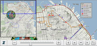
View the route map using the Zoomify Flash Viewer.
This allows you to zoom and pan the route map much the same way that Google maps does it. Won't work on iPads or iPhones.
Click on the image above to go to the external site hosting the Zoomify Viewer and the tile server hosting the map.
Download the Turn Sheets in PDF format.
 Click on the thumbnail.
Print these turn sheets and take with you on the ride. Fold the page lengthwise with the printing on the outside. Then fold again to 1/4 page size. Then clip onto or insert into the window of your handlebar bag or whatever.
|
View the route online via these JPEG image links.
Or, download into your smart phone to view while on the ride, in case you lose the group, need to find a nearby bike repair shop, restroom or water fountain.

 Click on the thumbnails.
The wiki will show an unreadable reduced image when you click the thumbnails above. Just click on the image again to view the full resolution map images. Or, click on the Full resolution link below the image.
Download the route maps in PDF format.
Then print and take along with you on the ride.

 Click on the thumbnails.
Clicking either image gives you the same PDF. The PDF is ~1 Mb and has been highly compressed to provide easier web delivery. While there are a lot of JPEG artifacts, the maps are still readable when printed. It would probably be best to print both maps in color, back-to-back on the same sheet.
|


