Difference between revisions of "San Francisco:Route"
JamesAZaun (talk | contribs) (Links the new uploaded route maps have been added.) |
JamesAZaun (talk | contribs) (Added instructions on how to view the map images at full resolution.) |
||
| Line 11: | Line 11: | ||
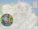
[[Image:SF_WNBR_Route_Map_2011_06_A_T.jpg|link=File:SF_WNBR_Route_Map_2011_06_A.jpg]] | [[Image:SF_WNBR_Route_Map_2011_06_A_T.jpg|link=File:SF_WNBR_Route_Map_2011_06_A.jpg]] | ||
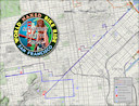
[[Image:SF_WNBR_Route_Map_2011_06_B_T.jpg|link=File:SF_WNBR_Route_Map_2011_06_B.jpg]] | [[Image:SF_WNBR_Route_Map_2011_06_B_T.jpg|link=File:SF_WNBR_Route_Map_2011_06_B.jpg]] | ||
| + | <br /> | ||
| + | The wiki will show an unreadable reduced image when you click the thumbnails above. Just click on the image again to view the full resolution map images. Or, click on the '''full resolution''' link below the image. | ||
|width="50%" style="padding-left: 1em;" valign="top"| | |width="50%" style="padding-left: 1em;" valign="top"| | ||
*Download the route maps in PDF format. Then print and take along with you on the ride. | *Download the route maps in PDF format. Then print and take along with you on the ride. | ||
Revision as of 19:23, 8 June 2011
Home > List of rides > US > San Franscisco > Route

We finally have the June 2011 route nailed down. We tried to use Google's map routing tool to do this but it was just a disaster. So, we are providing the route in a printable PDF format along with some JPEG images that you can view online.
Route Maps
2011
Northern Hemisphere Route Maps (June)
|
|