Difference between revisions of "File:Wnbr2012route.png"
Leifharmsen (talk | contribs) (This is the proposed Toronto route for 2012. It differs from 2011 only at the ending, where it arrives first at the park by the Toronto Island Ferry Docks with accommodation for those who wish to continue on to the starting point at Coronation Park.) |
|||
| Line 1: | Line 1: | ||
This is the proposed Toronto route for 2012. It differs from 2011 only at the ending, where it arrives first at the park by the Toronto Island Ferry Docks with accommodation for those who wish to continue on to the starting point at Coronation Park. | This is the proposed Toronto route for 2012. It differs from 2011 only at the ending, where it arrives first at the park by the Toronto Island Ferry Docks with accommodation for those who wish to continue on to the starting point at Coronation Park. | ||
| + | |||
| + | [[Category:Maps 2012]] | ||
Latest revision as of 00:31, 7 March 2022
This is the proposed Toronto route for 2012. It differs from 2011 only at the ending, where it arrives first at the park by the Toronto Island Ferry Docks with accommodation for those who wish to continue on to the starting point at Coronation Park.
File history
Click on a date/time to view the file as it appeared at that time.
| Date/Time | Thumbnail | Dimensions | User | Comment | |
|---|---|---|---|---|---|
| current | 03:38, 2 May 2012 | 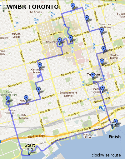 | 400 × 509 (344 KB) | Leifharmsen (talk | contribs) | This is the proposed Toronto route for 2012. It differs from 2011 only at the ending, where it arrives first at the park by the Toronto Island Ferry Docks with accommodation for those who wish to continue on to the starting point at Coronation Park. |
- You cannot overwrite this file.
File usage
There are no pages that link to this file.