File:Toronto map.png
No higher resolution available.
Toronto_map.png (280 × 280 pixels, file size: 34 KB, MIME type: image/png)
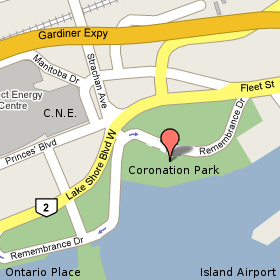
This is a map showing where we gather at Coronation Park, at the centre of the park by the lake. Coronation Park is between the Island Airport and the CNE, not far from the foot of Bathurst Street.
File history
Click on a date/time to view the file as it appeared at that time.
| Date/Time | Thumbnail | Dimensions | User | Comment | |
|---|---|---|---|---|---|
| current | 00:20, 15 May 2008 | | 280 × 280 (34 KB) | Leifharmsen (talk | contribs) | This is a map showing where we gather at Coronation Park, at the centre of the park by the lake. Coronation Park is between the Island Airport and the CNE, not far from the foot of Bathurst Street. |
- You cannot overwrite this file.
File usage
There are no pages that link to this file.